

SYTADIN

Description of SYTADIN
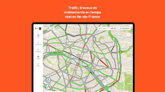
Sytadin is a mobile application designed to provide users with real-time traffic information for motorways and national roads in the Île-de-France region of France. This application is available for the Android platform and can be downloaded for free. Sytadin is developed by the Île-de-France Roads Department (DiRIF), a public service responsible for the management and development of the road network in the capital region.
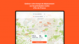
The app features a user-friendly interface that allows for easy navigation. It presents an enhanced map that provides precise information on road conditions. Users can access personalized information through a feature called My Sytadin, which allows them to set and track their favorite routes. This customization enables users to receive updates relevant to their specific travel needs.
Sytadin includes a virtual SOS terminal that helps users contact emergency services quickly based on their geolocation. This feature is particularly useful in urgent situations, ensuring that assistance can be summoned without delay. The app prioritizes user safety and convenience, making it an essential tool for anyone traveling on the road.
Reliable information is a cornerstone of the Sytadin application. All events reported within the app are verified by traffic specialists from the Île-de-France Roads Department. These specialists cross-check information with various sources to ensure accuracy, which contributes to the reliability of the updates provided. Users can trust that the information they receive has undergone thorough scrutiny.
Real-time updates are another critical aspect of Sytadin. The application sources its information directly from a network of sensors installed across the roadways, as well as from intervention teams and traffic cameras. Data is also collected from vehicles in circulation, which enhances the comprehensiveness of the traffic information available. This continuous flow of data allows users to stay informed about current road conditions.
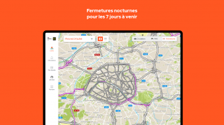
The app also provides provisional information regarding planned road closures, particularly useful for those who may be traveling in the coming days. This feature includes details on roadwork and other events that may impact traffic flow, allowing users to plan their journeys accordingly. The inclusion of future road closures helps mitigate travel disruptions.
Sytadin categorizes events based on their nature, such as incidents, breakdowns, accidents, or roadwork sites. Each event is accompanied by specific details, including its location, origin, and a description of the situation. Users can also find information about the impact on traffic and, when available, an estimate of how long disruptions are expected to last. This organized presentation of information aids users in making informed decisions about their travel routes.
The application does not include any commercial advertising, which contributes to a clean and focused user experience. This aspect allows users to concentrate on the information that matters most without distractions. Sytadin’s commitment to providing clear and essential information is evident throughout its design and functionality.
Users can easily navigate through the app to find the information they need. The map feature allows for zooming in and out, providing a broader or more detailed view of the traffic situation. This flexibility in viewing options ensures that users can access the level of detail they require, whether they are planning a long trip or simply checking local traffic conditions.
Sytadin is particularly beneficial for both residents and visitors to the Île-de-France region. For those unfamiliar with the area, the app offers insights into local traffic patterns and potential problem areas. Residents can utilize the personalized features to keep abreast of daily commutes and any changes in traffic conditions that may affect their routes.
The development of Sytadin reflects a commitment to enhancing travel experiences in the Île-de-France region. By integrating advanced technology and reliable data sources, the app meets the needs of modern travelers. Its emphasis on accurate, real-time information positions it as a valuable resource for anyone navigating the region’s roadways.
In conclusion, Sytadin is a comprehensive tool designed to provide essential traffic information for users traveling in the Île-de-France area. With its user-friendly interface, personalized features, reliable updates, and focus on safety, the app serves as a crucial resource for both daily commuters and occasional travelers alike.
For more information, users can visit the official website of the Île-de-France Roads Department.


